 ecoNEWS VT
Twenty Years of Aerial Forest Monitoring
Apr. 26th 2016The Vermont Department of Forests, Parks, and Recreation (VT FPR) and the US Forest Service conduct aerial surveys annually to map the extent and severity of current year forest injury. This type of landscape scale assessment complements plot-level field assessments of forest condition and has proven useful in detecting new health issues.
Aerial sketch mapping is an efficient and economical way of detecting visible forest change events over large forested areas. These surveys provide much more information than simply identifying the location of stress symptoms. Expert sketch mappers are able to include information on the cause, extent, severity and type of forest damages. This type of landscape scale assessment serves as the basis for recommending treatment alternatives.
The data set analyzed in the Vermont Monitoring Cooperative Long-Term Monitoring Update was the last 20 years of digital data. Statewide data is collected by the VT Department of Forests, Parks, and Recreation, while the US Forest Service collects data over the Green Mountain National Forest and other federal lands.
Damage agents fall into three categories:
- Minor – limited impacts occurring infrequently and causing little damage
- Chronic – Locally important impact, occurring in many or most years, but rarely causing damage over a wide area. Many chronic damages are related to site, as in drought or a wet site. Others are endemic pests that are host-specific, and cause repeated impacts only where their hosts are present and susceptible.
- Episodic – infrequent, but significant in extent of damage. Some of these are directly related to weather events, others are biotic.
These should be considered conceptual groups, as specific damage causing agents would be classified differently if another time period was examined.
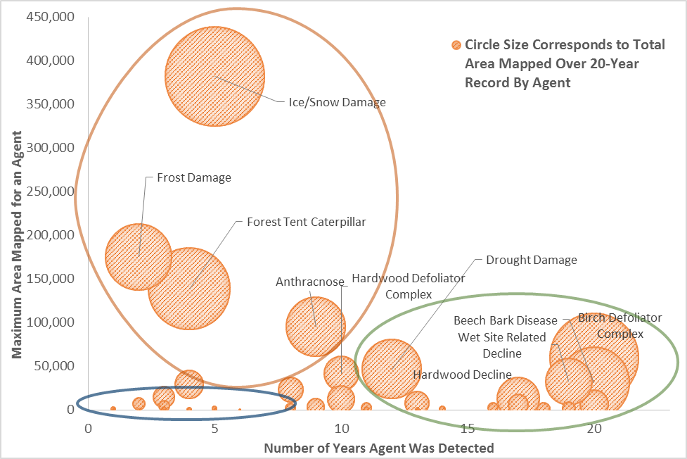
Over the past 20 years, aerial surveys have detected dozens of types of forest damage, although widespread dieback and mortality are rare. Damage occurs every year but the damage agents and extent of damage vary widely.
Beech bark disease, birch defoliators and hardwood decline are the most commonly mapped damage agents, but the ice storm of 1998 caused the most widespread damage. Weather is a common driver or contributor to forest decline (most symptoms are consistent with dry conditions).
Over the past 25 years the total mapped damaged area has been generally declining but the yearly variability and episodic nature of many stressors indicate that high damage years are still likely.
 Moving forward, maintenance of long-term metrics will be essential. Several invasive insects and diseases have been detected close to Vermont's borders. Under a warming climate, increases are expected in extreme weather events, such as ice storms, wind, drought, and flooding, and in defoliator outbreaks. Continued annual aerial surveys will provide critical information about the impact of these stressors on the forest and help inform resource management.