 ecoNEWS VT
Shifting Seasons: Developing a Standardized Method for Estimating the Start of Spring
Oct. 1st 2014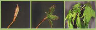
Researchers have noted a trend of earlier spring budburst over the past several decades based on date of tree leaf out and other phenological metrics from field measurements across the northeastern United States. In order to assess if these trends witnessed at long term monitoring sites extend across the larger region Katharine White compared several remote sensing methods to predict spring leaf out as part of her Master of Science research in the Rubenstein School of Environment and Natural Resources at the University of Vermont. Results were recently published in the Remote Sensing of Environment journal. The ability to note changes in shifting seasons across the northeastern United States is invaluable information, helping to understand long-term trends and spatial patterns in the response of spring phenology to climate change. However, quantifying how much the seasons have shifted using remote sensing methods in the northeast has been difficult due to a heterogeneous landscape, cloudy spring weather, and a lack of standard methods. Remote sensing and reflectance indices are often used in quantifying the amount of greenness on the landscape, but the availability, quality and information necessary to interpret this type of data is limited. The researchers sought to identify the most accurate methods to use in the Northeast, while considering the effects of the heterogeneous landscape, spring cloud cover, and the common presence of snow in the spring. Multi-temporal Landsat TM and ETM+ satellite spectral data were compared with field measurements of phenology and canopy metrics to identify the most accurate combination of spectral indices, sigmoidal logistic fit models and index thresholds for phenology assessments. A variety of field sites, including a range of elevations, forest cover types, and landscape positions were used to help account for the heterogeneity of the northeastern landscape. Phenology was classified using a ranking system, from dormancy to leaves fully expanded. These classifications were made in the field, and then used in conjunction with the satellite and reflectance data to create models for the spring “green-up” period. The researchers used these comparisons to identify a standardized method for estimating the start of spring in the Northeast. Analyses of phenology across the landscape indicate that while spring leaf out is significantly correlated with field metrics and can be predicted to within nine days, accuracy is impaired by missing imagery dates due to cloud cover and in stands with mixed hardwood/conifer species composition. This information is critical to interpreting trends in spring phenology commonly reported in the literature. The research can specifically be used to analyze long-term data to determine changes over time in the start of spring. The researchers are further using this method with a 25-year archive of satellite imagery to look at long-term changes, inter-annual variability, and spatial patterns in phenology. Initial results demonstrate that approximately 75% of Vermont’s forested landscape has been trending towards an earlier spring, averaging a half day earlier each year.