 ecoNEWS VT
The Health of Northeastern Forests
Apr. 21st 2021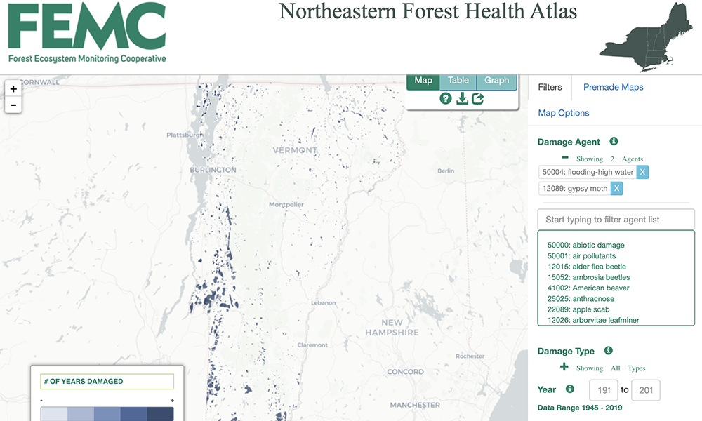
Forests are vital and complex ecosystems. Among many other things, they are home to watersheds, offer habitat for wildlife, and provide a vast array of benefits for humans. However, forest health is threatened by a number of different factors, all of which are becoming more risky due to climate change.
In an effort to catalogue the health of New England and New York forests, the Forest Ecosystem Monitoring Cooperative (FEMC), has created the Northeastern Forest Health Atlas. The Atlas catalogues 190 damage agents for over 101 years for forests in the six New England states (Vermont, Maine, Rhode Island, New Hampshire, Connecticut, Massachusetts) and New York. The purpose of the Atlas, in the words of FEMC Director James Duncan, is to “improve access to standardized data related to forest disturbance across both space and time for forest managers and researchers.” Through the Atlas, the user can glean a detailed picture of how many acres of Vermont forest have suffered from discoloration due to birch leaf fungus over the past hundred years, or how many southern Vermont forests have been affected by tent caterpillar in the last fifty years.
The Atlas is a robust compilation of data from two main sources. The first is aerial detection surveys and insect and disease surveys performed by federal and state agencies with support from the US Forest Service. These surveys, conducted using small aircraft, have been going on for decades in some states. The second source of data comes from forest health field research on the ground, mostly from studies funded by the Northeastern States Research Cooperative.
To use the Atlas, the FEMC suggests that you take the tutorial which can be accessed on the “Getting Started” tab from the pop-up window that emerges once you load the Atlas page. This will explain how you can search the Atlas for specific damage agents, which are cataloged according to their common name, Latin name, and US Forest Service code. You can also adjust the data to depict any range of years from 1918-2019. There are 12 damage types including defoliation, top kill, and branch flagging. All of these options create a multidimensional picture of northeastern forest health over the past 100 years based on a massive body of government research.
The Atlas can yield a detailed picture of certain forest systems and trends. High water and flooding are seen in every state in the Atlas, and the most frequent type of damage resulting from flooding is mortality. This is also the case for saltwater injury damage to coastal forests in Long Island and Massachusetts. (No flooding damage data was recorded prior to 1976.) In Vermont, the flooding is widespread across the state, including in the Champlain Islands. These analyses suggest that both inland and coastal forests will need robust flood-mitigation measures to protect them from the increasing frequency of storms and floods due to climate change.
The Atlas also offers a number of premade maps, highlighting specific topics of concern for the FEMC. For example, three premade maps highlight different kinds of damage caused by the gypsy moth. The gypsy moth has been causing defoliation across tens of thousands of acres of forest in Massachusetts since the early 1980s. The atlas also shows that by 2017 the gypsy moth caused defoliation throughout Rhode Island. Furthermore, forests in the survey area, as far west as the area south of Buffalo, New York, have been suffering from defoliation as a result of the gypsy moth since 2013. This Atlas allows forest professionals to chart these long-term trends and be better able to respond to the spread of certain invasive species.
Interactive, engaging ways to visualize data will be crucial as scientists and practitioners work to understand the intricacies behind how we must care for our forests today and into the future.